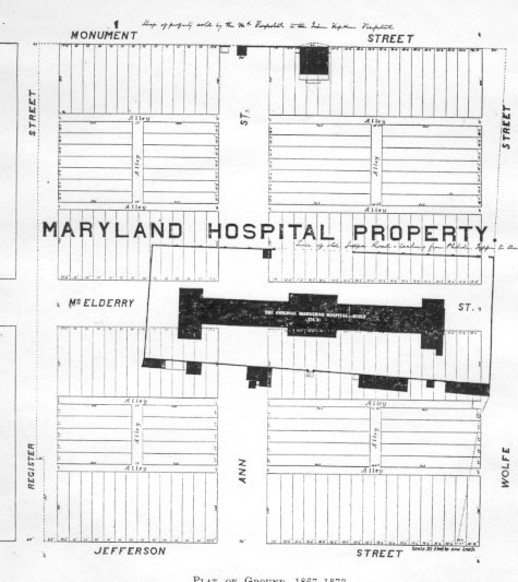
 The through-streets and building lots shown in the drawing at right, never actually existed. Instead, the map evidently was prepared in, or around, 1868 as part of an effort to establish the pecuniary value of the property -- in anticipation of its being put on the market for sale. According to documents from the time, the Board of Visitors wanted to show potential buyers that the property would lend itself to residential development. The drawing was used to were included with an estimate of the value of the property, were the old asylum buildings to be demolished, through-streets and alleys established, and the property subdivided into individual building lots. For a number of years there had been proposals to substantially expand the hospital in it's original Baltimore City location. Later, after construction on the new hospital in Catonsville was begun in 1853, consideration was given to the idea of maintaining hospital facilities at both sites; either as a single hospital with two locations, or as two separate hospitals with separate governance.
In 1868, the "new Hospital," also known as the Spring Grove Asylum, in Catonsville, was still only partially completed, and there seemed to be little realistic hope that sufficient funds would be identified at any time in the near-future to both finish the new hospital in Catonsville and to repair and upgrade the aging structures that continued to house the Maryland Hospital for the Insane at Baltimore, in the location that it had occupied continuously since 1798. Accordingly, by 1868 the Hospital's President and Board of Visitors seemed to have come to the conclusion that the best course of action would be to sell the Baltimore City property, so that the funds could be used to complete the Catonsville facility. Note the superimposed "footprint" of the Maryland Hospital, along with schematics that show the location of the wall the surrounded the hospital, as well as its outbuildings. Annual reports from the Maryland Hospital (at Baltimore) indicate that the outbuildings included a stable, a barn, a "straw house," a wash house, a drying house, and others. In all likelihood, these outbuildings are those shown in outline along the lower edge of the Hospital's southern wall. The building shown in outline at the top of the drawing, on the south side of Monument Street, was the Medical Superintendent's House -- a structure that was built in 1847 for that purpose. Records indicate that the small building, shown in silhouette below the letter "P" in the word "Hospital" was a gatehouse that was built to allow patients to be brought to the hospital during the night.

